Pico De Loro New Trail
Feb 15, 2015
I haven't climbed a mountain for around 8 months now so when Summit Outdoor Team created an event called "Walang Forever Climb" I quickly joined the event.

We started at 8:30 in the morning and we were greeted by rocks that looks like from a dry river. But I was actually amazed by how fresh the environment was. They say the trail has been opened to public just a week ago and that explains why lots of lichens can be found among trees and rocks along the trail.

After around 15 minutes of walking, we passed by this river flowing with fresh water.

After walking through a rocky path for around 30minutes, it becomes forested with mud on the ground. No more signs of rocks from the river and so the path becomes more stable and less slippery.

 The trail is basically a continuous ascent and in some parts of the trail, you have to literally hold on to roots and vines from big trees to make it easier to climb the steep and slippery parts.
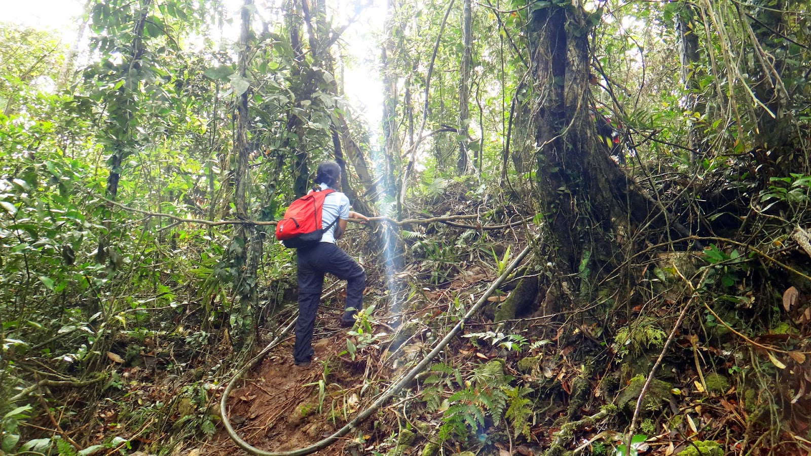
It is also noticeable that there are some roots and vines lying on the ground which can make a person trip over. This is expected given that the trail is new so better be cautious about your steps.
The whole trail is filled with large trees and it is widely forested so the heat of the sun will never be a problem. For most of my time climbing the trail, I could hear birds chirping and this is a good sign because it shows that the place is still rich where birds can thrive.


However, some humans just do not know how to take care of mother nature. I saw numerous candy wrappers and used wet wipes along the trail. I hope people will be educated more on their responsibility as stewards of the earth.
At around 10:00am, we reached a place where you can see the nearby mountains and it was a refreshing view. It was I think the only view I saw after hours of walking along the trail.

After walking for 30 minutes (we took a take 5 rest in between), we saw the view of the summit and the monolith. Then, we knew that we were actually near the campsite. We got surprised by stray (mountain) dogs in the trail and we realized they are from the campsite.

After another 30 minutes of walking, we finally reached the nearest campsite before the summit.

This was the most crowded campsite that I have been to. I realized that this mountain is highly commercialized. There were people EVERYWHERE literally and they are from different walks of life. It felt like I was in a high school fair or something, seriously. It was that crowded.
I think there were three sari-sari stores in the campsite and the prices of the drinks are also too steep as compared to other mountains that I've been to. However, it was good that tables made of bamboo were provided at the campsite. Use of CR also costs 5php. As I've written, this is a HIGHLY COMMERCIALIZED mountain.
We walked around the campsite and on the left side was a spot where you can take a picture of the monolith and the summit.
After walking and exploring the place, we went on a table and ate our lunch there. We rested for around 15 minutes then went for the summit.
The trail to the summit was a continuous ascent. On the first part, there will be rocks and trees where you will have to hold on to climb some 45-degree assault. The second part which is the actual assault to the summit was very slippery and comprised of dry, loose soil. There was no rope to hold on so you have to crawl or balance yourself well so that you will not slip down. I recommend to step on the grass so that you will not have to crawl or slide down in the trail.
Upon arriving at the summit, you will have a 360-degree view of the place.


Across the summit is the monolith where you also have to wait for your turn to climb

After around an hour of waiting, here are our friends who made it on top of the monolith.


When it was around 3:30 P.M., we left the campsite and headed back to the DENR station. The way back was faster because we didn't rest that much. We were actually worried to do a night trek because not all of us had headlamps so we did a faster pace.
By around 4:45 P.M., we were already near the river at the start of the trail. We freshen up a bit by washing our arms and faces with the cold water flowing from the river.

By 5pm, we were already at the DENR Station. We took a bath in the makeshift comfort room and then prepared to go back to the city.
Notes:
1. You can buy food at KFC or 7-eleven across coastal mall or you may choose to buy at the DENR site. It costs 70/meal.
2. As responsible people visiting the mountain, please practice LNT (Leave No Trace). Let's keep the mountain clean. Put your garbage, even if it's just a candy wrapper in your bags or pockets. The new trail is still "new" but there were already trash found along the trail.


I haven't climbed a mountain for around 8 months now so when Summit Outdoor Team created an event called "Walang Forever Climb" I quickly joined the event.
Pico De Loro is one
of the mountains that is around 2 hours away from Manila. It is an easy hike and newbies can easily climb to its summit and back. The place is referred to as Pico De Loro because its summit
looks like the beak of a parrot.

Contrary to popular notion, the real name of the mountain is Mt. Palay-Palay.
Contrary to popular notion, the real name of the mountain is Mt. Palay-Palay.
Interestingly, there is a big rock called The Monolith near the summit
which can be climbed. This makes the whole experience more interesting.

The mountain has two trails: the old and the recently opened new trail. I personally haven't experienced climbing via the old trail but they say it is a gradual climb and the trail is shaded by trees.
The new trail is also characterized by a forested trail and it was an easy breezy climb. However, I do not recommend this trail when it is raining or when it has rained the day before your climb because it has some 60 degrees ascent/descent which makes the trail slippery and harder to climb.
Before starting the climb, we registered at the DENR station and did some photo-ops.
 |
| The Group. Credits to sir "Logan Claws" for this picture. |
We started at 8:30 in the morning and we were greeted by rocks that looks like from a dry river. But I was actually amazed by how fresh the environment was. They say the trail has been opened to public just a week ago and that explains why lots of lichens can be found among trees and rocks along the trail.
After around 15 minutes of walking, we passed by this river flowing with fresh water.
After walking through a rocky path for around 30minutes, it becomes forested with mud on the ground. No more signs of rocks from the river and so the path becomes more stable and less slippery.
It is also noticeable that there are some roots and vines lying on the ground which can make a person trip over. This is expected given that the trail is new so better be cautious about your steps.
The whole trail is filled with large trees and it is widely forested so the heat of the sun will never be a problem. For most of my time climbing the trail, I could hear birds chirping and this is a good sign because it shows that the place is still rich where birds can thrive.
However, some humans just do not know how to take care of mother nature. I saw numerous candy wrappers and used wet wipes along the trail. I hope people will be educated more on their responsibility as stewards of the earth.
At around 10:00am, we reached a place where you can see the nearby mountains and it was a refreshing view. It was I think the only view I saw after hours of walking along the trail.
After walking for 30 minutes (we took a take 5 rest in between), we saw the view of the summit and the monolith. Then, we knew that we were actually near the campsite. We got surprised by stray (mountain) dogs in the trail and we realized they are from the campsite.
After another 30 minutes of walking, we finally reached the nearest campsite before the summit.
This was the most crowded campsite that I have been to. I realized that this mountain is highly commercialized. There were people EVERYWHERE literally and they are from different walks of life. It felt like I was in a high school fair or something, seriously. It was that crowded.
I think there were three sari-sari stores in the campsite and the prices of the drinks are also too steep as compared to other mountains that I've been to. However, it was good that tables made of bamboo were provided at the campsite. Use of CR also costs 5php. As I've written, this is a HIGHLY COMMERCIALIZED mountain.
We walked around the campsite and on the left side was a spot where you can take a picture of the monolith and the summit.
 |
| My Souvenir Photo |
The trail to the summit was a continuous ascent. On the first part, there will be rocks and trees where you will have to hold on to climb some 45-degree assault. The second part which is the actual assault to the summit was very slippery and comprised of dry, loose soil. There was no rope to hold on so you have to crawl or balance yourself well so that you will not slip down. I recommend to step on the grass so that you will not have to crawl or slide down in the trail.
Upon arriving at the summit, you will have a 360-degree view of the place.
 |
| People at the summit |
Across the summit is the monolith where you also have to wait for your turn to climb
 |
| Waiting for their turn to climb the monolith |
After around an hour of waiting, here are our friends who made it on top of the monolith.
When it was around 3:30 P.M., we left the campsite and headed back to the DENR station. The way back was faster because we didn't rest that much. We were actually worried to do a night trek because not all of us had headlamps so we did a faster pace.
By around 4:45 P.M., we were already near the river at the start of the trail. We freshen up a bit by washing our arms and faces with the cold water flowing from the river.
By 5pm, we were already at the DENR Station. We took a bath in the makeshift comfort room and then prepared to go back to the city.
Notes:
1. You can buy food at KFC or 7-eleven across coastal mall or you may choose to buy at the DENR site. It costs 70/meal.
2. As responsible people visiting the mountain, please practice LNT (Leave No Trace). Let's keep the mountain clean. Put your garbage, even if it's just a candy wrapper in your bags or pockets. The new trail is still "new" but there were already trash found along the trail.
Sample Itinerary:
Estimated Expenses:


Hi Madam,
ReplyDeleteGood evening.
Mandatory po ba ang guide sa Pico? If ever how much ang guide? kung di naman need mag guide, wala bang ligaw via new trail?
Thanks,
Hi Joshua. Hindi naman mandatory ang guide sa Pico via new trail. I have no idea kung how much ang guide since we didn't have one when we climbed. Wala rin ligaw. Well-established naman ang trail kahit newly opened.
DeleteHi there! Is it allowed to stay overnight at Pico de Loro?
ReplyDeleteThanks.
Hi Mac. I am really sorry for this late reply but yes, it is allowed.
DeleteThis comment has been removed by the author.
ReplyDeleteHi! Can we like, set up our tent and leave it unattended at the campsite? Is it safe?
ReplyDeleteHi, sorry for this late reply. I've never camped there actually but I guess it's always better to keep an eye out on your things because there's really a lot of people in the campsite.
DeleteHi sir,
ReplyDeleteWe went to Pico last June this yr & overnight camping was not allowed for the mean time by that time. Do you have any idea if overnight camping is now allowed? Also, do you have contact @ pico wherein I can reach & confirm things about overnight camping. Thanks :)
Hi Regie,
DeleteBabae po ako. Haha! I'm Ruth, the author of this blog. :) I am sorry but I have no contacts for Pico De Loro Mountain and I'm also not sure if overnight camping is allowed now.
Hi! Paano po pumunta ng Pico de Loro if manggaling kami sa Alabang? Ano po ang sasakayan namin? Mga magkano po kaya ang expenses namin? We are planning to go there by November. Hope you reply. Thanks!
ReplyDeleteHi Donna. I'm sorry I did not see this comment sooner. Pero hindi rin ako marunong magpunta ng Pico galing Alabang. Hehe.
DeleteFor the expenses, I placed an expenses table at the bottom of the blog.
DeleteGood day Mam!
ReplyDeleteHi! My name is Adreana Remo from DENR. I saw your photos Mt Palay palay. I would like to ask if you would be interested to contribute photos for the Coffeetable book that we are making. The book will feature the 17 protected areas in calabarzon region and one of the highlights of the book will be the ecotourism sites that are found in the area.
We understand the difficulty of getting photos like this so rest assured that due credits will be given to you and that we will give you a complementary copy.
Hope to hear a positive response from you. And we hope that you could help us in showcasing the beauty of CALABARZON thru this book. Thank thank you very much po!
Sincerely yours,
Adreana (reannesantos@gmail.com)
Hi Adreana,
DeleteThank you for your interest in my photos. Yes, I would love to contribute to your project. Would you like me to email the high-res version of any of these photos?
Respectfully,
Ruth
Nice photos and details input, thanks for sharing Ruth. Were having a weekday climb this March I hope it won't be a jam-packed as much as possible.
ReplyDeleteHi Mary Ann, thanks! Yeah, I also hope you'll have a good time there. :)
Delete